top of page


Call Today: 651-410-7033
Is Your Project Too Important for Unverified Data and Generic Photos?
Then you need -
Advanced Aerial Mapping, LiDAR, Thermal and Forensic Imaging Services
Your clients demand precision. We deliver the solution. We bridge the gap with engineering-grade LiDAR, thermal diagnostics, and forensic imagery—giving you the defensible data you need to satisfy your most demanding stakeholders.
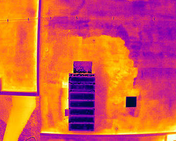
Thermal Imaging & Analysis Don't guess. Know.
We transform anomalies invisible to the naked eye into objective, measurable data—helping you prevent failure, identify areas of concern, and validate claims.

Aerial Mapping & 3D Modeling The Measurable Digital Twin.
We transform physical sites into centimeter-accurate virtual assets. Using photogrammetry and LiDAR, we deliver forensic-grade data to measure, inspect, and validate projects—even through dense vegetation.
High-Resolution Imaging Objective Visual Evidence.
We provide pin-sharp drone photography designed not as art, but as verifiable proof—ensuring your evidence stands up to scrutiny for legal claims and engineering inspections.


bottom of page