top of page


Call Today: 651-410-7033
Is Your Project Too Important for Unverified Data and Generic Photos?
Then you need -
Advanced Aerial Mapping, LiDAR, Thermal and Forensic Imaging Serving the Twin Cities, Western Wisconsin, and the Greater Midwest
Your clients demand precision. We deliver the solution. We bridge the gap with engineering-grade LiDAR, thermal diagnostics, and forensic imagery—giving you the defensible data you need to satisfy your most demanding stakeholders.
NEW: Indoor LiDAR & As-Built Scanning. Turn your job site into a 3D Digital Twin instantly.
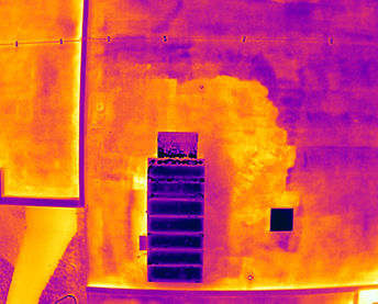
Thermal Imaging & Analysis Don't guess. Know.
We transform anomalies invisible to the naked eye into objective, measurable data—helping you prevent failure, identify areas of concern, and validate claims.

Aerial Mapping & 3D Modeling The Measurable Digital Twin.
We transform physical sites into centimeter-accurate virtual assets. Using photogrammetry and LiDAR, we deliver forensic-grade data to measure, inspect, and validate projects—even through dense vegetation.
High-Resolution Imaging Objective Visual Evidence.
We provide pin-sharp drone photography designed not as art, but as verifiable proof—ensuring your evidence stands up to scrutiny for legal claims and engineering inspections.

ScenePhoto360, LLC
bottom of page